 |
|
|
Follow Mark on Facebook for more stories |
||
|
1986 Flood Disaster In keeping with the familiar weather proverb, the month of March roared in like a lion this year. At first heavy rain threatened to flood portions of western Nevada (again), which was quickly followed by colder storms that dumped several feet of snow at the higher elevations. Fresh powder mantled the landscape just in time to revitalize the winter scenery for the annual North Lake Tahoe Snow Festival.
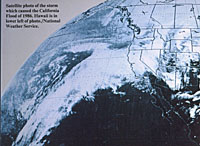
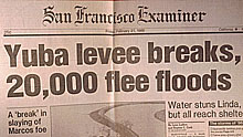
Statistically, a damaging flood on the Truckee River occurs every eight years or so. That statistic is just an average, but ironically the 2005 New Years flood event happened exactly eight years after the highly destructive New Years flood of 1997. Twenty years ago, in February 1986, one of the greatest and most widespread floods on record devastated California and Nevada with phenomenal amounts of precipitation. On February 11, 1986, a vigorous low pressure system drifted east out of the Pacific. The slow-moving storm meandered south where it tapped into warm moist air from the tropics. Suddenly it was laden with abundant moisture and heading straight for California. The Golden State and the Sierra were force-fed this "tropical cocktail" for 10 days. Unprecedented amounts of rain pounded the state. The heaviest 24-hour rainfall ever recorded in the Central Valley, 17.60 inches, occurred on Feb. 17, 1986, at Four Trees in the Feather River Basin. At Calistoga, 29 inches of rain in 10 days created a once-in-a-thousand-year rainfall event.
The lowlands of California certainly suffered, but this "Pineapple Express" also saved a potent punch for the Sierra and Western Nevada. Rainfall totals were incredible. In just nine days nearly 10 inches of rain drenched Carson City, setting a new monthly precipitation record. Not bad for a city that receives less than 12 inches in an average year. Due to the storm's tropical nature, snow levels fluctuated between 7,000 and 8,000 feet. Between Feb. 11 and Feb. 20, 1986, more than 17 inches of rain fell at the Truckee Ranger Station. Water-logged observers at Blue Canyon on the Sierra west slope tallied nearly 34 inches of rain in the same ten days. Above 8,000 feet storm total estimates ranged from 15 to 20 feet of new snow with 20-30 inches of water content. Disappointed ski resort officials complained that the weather improved slope conditions, but due to negative media coverage of the storm, the three-day President's weekend crowds were smaller than usual. The media didn't have to spin a negative message; the storm was brutal. Slushy snow clogged Donner Pass and Echo Summit delaying thousands of frustrated holiday travelers. Sturdy pines collapsed under the sodden snow load taking power lines with them. Scattered blackouts plagued the region. An avalanche 300 yards wide blasted through the Third Creek canyon above Incline, Nevada. Trees 200-feet high were snapped at their base. The slide wiped out a utility road and a municipal water line, but damaged no homes. There were no injuries and sheriff's deputies quickly implemented a voluntary evacuation order.
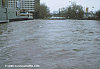
Despite an extensive flood control system, millions of gallons of water raced into the Truckee River. Shortsighted and destructive logging and grazing practices over the last 100 years intensified the runoff. The loss of water-absorbing plants and trees coupled with accelerated runoff from roads, parking lots and rooftop areas transformed the normally peaceful Truckee River into a raging torrent. Downstream communities prepared for the worst. In the Carson Valley hundreds were evacuated. In Hidden Valley dozens of wild-eyed horses struggled in water chest high. Reno was virtually sealed off when floodwaters surrounded the "Biggest Little City" and cut off all roads except Interstate 80 east. (In the Tahoe Basin mud and rock slides closed several roads.) Riverfront casinos in downtown Reno sandbagged their buildings but hundreds of stranded tourists kept the slot machines ringing steadily. The persistent rain and flooding continued unabated. On Feb. 19, the Truckee River literally exploded. A 12-inch natural gas pipeline underneath the river ruptured near Wadsworth. A plume of escaping gas shot 15 feet into the sky through the muddy torrent. About 42,300 residences and businesses from Fallon to Lake Tahoe were without gas for heating and cooking for more than a week. The storm broke two days later. The flood caused $17 million in damage and five western Nevada counties were declared Federal Disaster Areas. Due to extensive development in western Nevada during the last 20 years since the 1986 flood, a similar event today would cause much more significant destruction.
Due to the 1986 flood, Folsom Dam operators now leave twice the empty space for water storage at the beginning of each rainy season. Managers are also much more aggressive at releasing excess water sooner than later and more of it. The new policies at Folsom Dam proved vital in the 1997 New Years flood. On this side of the mountain, however, improvement in water management policy and infrastructure has been less productive. According to a 2005 Reno News & Review article about the 1997 New Years flood, Michael Steele, senior administrative analyst and emergency management coordinator for the city of Sparks stated, "The problems that existed in the Truckee River at the time of the ['97 ] flood were that nothing was ever done after the '86 flood. The Corps of Engineers came in, did a huge, very expensive study, recommended tens if not hundreds of millions of dollars of improvements, but when they looked at the plan and they weighed it against how much cost would be for benefit—the B/C ratio—the benefit/cost ratio fell below 1, and they will not do a project if it does that." A March 1992 letter to US Senator Harry Reid from Col. Laurence R. Sadoff of the US Army Corps of Engineers was very clear: "I am writing to inform you of our decision to reclassify the Truckee Meadows project to a deferred status. Our current evaluation indicates that the project is not economically feasible. The deferred status suspends all preconstruction engineering and design activities on the project." Managing the Truckee River and Lake Tahoe water levels is a complicated business and improving flood control infrastructure in western Nevada must be accompanied by a sensible water management policy upstream in California. There is still much to be done. |
|||||||||||||||||||||||||
|


